Pages

Wednesday, July 1, 2020

Sheltering in (a Breathtaking) Place: My Last Pre-pandemic Adventure


It was a warm spring day in mid-March, and I didn’t look like a typical BART commuter. I shouldered a full-sized (though ultralight) backpack crammed with cold weather layers, a zero degree sleeping bag and a bear-proof food canister. In my hands I carried a canvas bag with an awkward jumble of snowshoes, hiking stick, snow shovel and fleece-lined snow boots.
After multiple seasons of drought, national park shutdowns and some nasty health issues thrown in for good measure, the stars had finally aligned for this trip. Fresh Sierra snow awaited, more was forecast, and I was going snowcamping in Yosemite hooray!
Exiting the train station for my carpool meet-up, I balanced the bags on a shady cement seating area and scanned for a similarly geared up stranger. I fished a Purell wipe out of a pocket and washed my hands. A few texts later, I located my Sierra Club carpool crew and we launched into introductions.
The previous week had been a roller coaster of unsettling headlines. The WHO had declared a pandemic the day before, and no one knew what to make of it. As our car cruised through sparse highway traffic, the backseat passenger noted that school closures had just been announced in San Francisco.
I switched off my phone and beseeched my two cohorts not to share virus updates with me during our trip- just a short respite from the unspooling apocalypse. I’ve never taken my phone backpacking because I appreciate being off the grid and feeling present in the wilderness. Bad news can always wait.
Our pre-hike lodging just outside the park had hand sanitizer pumps mounted at every public entrance, and my soft-spoken roommate snored seismically. In the morning, our 7-person group caravanned to the winter road closure on Glacier Point Road and parked at the Badger Pass resort. Tantalizing powder frosted the hill but the lifts were deserted. Patches of snow and ice contoured the car-closed continuation of the road, though nothing appeared deep or treacherous, so most of us ditched our snowshoes & cautiously plodded on in snow boots. We encountered a handful of cross-country skiers carrying their skis on their way to the coveted Ostrander Ski Hut, and we swapped phones to snap group photos. After a short section of road walk, we veered off onto the snow-blanketed winter trail to Dewey Point and bid farewell to the skiers.
Our trek followed a tight cluster of footprints overlaid around faint ski tracks, like a frozen trail of 3D sheet music. When our route became indistinct, we searched for the bright yellow winter trail markers sporadically affixed high in the tree trunks. Traipsing through a marshmallowy white meadow, we navigated across the shallowest crossings of snow-crusted creeks, testing for solid footing before lumbering across with full packs. Some trail sections meandered through prickly tendrils of brush that snapped back behind you and threatened to whack tailgaters.
A few hours though just two and a half miles later, we reached an open expanse above the Yosemite Valley rim with a stunning panorama of granite peaks. Dropping our packs to worship from the Dewey Point overlook, we feasted on private views of El Capitan, Cathedral Rocks and the dramatic tips of Cathedral Spires. Walking in, we’d encountered just a few fellow hikers exiting the backcountry, and we reveled in the celestial solitude.
Back from the rim, in a clearing framed by sentinel evergreens, our trip leaders scouted a deep snow deposit where we would construct a communal camp kitchen. We set up our individual tents in dry-ish private nooks around it, and then shoveled and formed snow bricks to build a three-foot-high amphitheater snuggled beside a long snow table. As daylight receded and stars popped into view, we tied a line between the trees and draped a rope of colored lights overhead to make sitting in the cold darkness more festive. After eating dinner shoulder to shoulder in our tightly packed social zone, we shared whiskey and alfajores cookies.
Before melting snow to rehydrate or cook our dinners, we’d strolled to nearby Crocker Point, where we reveled at the gushing white line of Bridalveil Fall and the distant silhouette of Half Dome. Aqua blue sky descended into puffy clouds on the horizon, casting dramatic shadows and texture onto a never-ending vista of snow-capped knobs and sheer rock walls. Looking down into the Valley chasm, avalanche gullies streaked gray paths through precipitous slopes of forest.
Because it’s home to so many opportunistic (habituated) bears, Yosemite is one of the few places in the Sierra Nevada to require bear-proof food storage in winter. Before turning in for the night I puzzled over the best location to cache my bear canister so it was far enough away from camp (no overnight food raids, please!) but not so distant that it would be impossible to locate after the morning snowstorm to come.
I began hearing drops hit the tent as soon as I’d donned four clothing layers and zipped into my puffy down mummy bag. Though the temperature was close to freezing, the rapid taps sounded like rain, so I gathered my boots further under the rain fly and felt a wave of gratitude for my warm dry shelter. The wind picked up & stayed active all night, battering my low profile tent like a pesky speed bump.
My Dewey Point campsite in the morning
I awoke at daybreak to the sound of a zipper and the crunching of snow fading off towards the Valley rim. I peeked out to see a white dusted world and the foot of my tent sagging under hours of accumulated snow. Exiting my shelter, I knocked off the snow drifts and located my blue food canister in a seemingly new locale. My food partner was already up and boiling water for coffee and oatmeal, and I remarked at how decadent it felt to have someone making me breakfast in the backcountry.

The hike back was a transformed landscape of fresh unconsolidated snow and the footprints our group left behind in it. We unintentionally demonstrated the myriad ways to gracelessly posthole, at least once extracting someone buried up to their waist. The snow continued to fall, gusting into our faces and fogging up glasses and goggles.

As we departed Yosemite, arriving visitors were being stopped for tire chain controls, and we felt fortunate that we’d never had to chain up. On the drive back home, I silently ticked off some personal landmarks along Highway 120: the impossible-to-spot sign for Rainbow Pool, the white-knuckle descent of the Old Priest Grade, the melancholy remains of Chinese Camp, plus a helpful new traffic light at the junction of Highways 120 and 108.
A few days later, San Francisco Bay Area residents were ordered to “shelter in place,” as if an active shooter had taken the entire region hostage. Soon after, Yosemite itself was closed and the governor enacted a statewide stay at home order. Looking back, the trip seems like an improbable fantasy, a distant history where it was reasonable to venture out and explore the world, meet new people and talk face-to-face, masks weren’t ubiquitous accessories, and people didn’t cringe when strangers walked less than six feet away.

Wednesday, February 1, 2017

Never again!

It's been a while since I've posted here, but Trump's Executive Order banning refugees, legal residents, and Muslims from the U.S. has my blood boiling. Has this country not learned anything?!

The following is a reprint from an article I wrote for the March 30, 2005 edition of the San Francisco Bay Guardian:

Civil wrongs

Speeding down scenic Highway 395, many drivers don’t notice much beyond the snow-covered vistas of Mount Whitney and its environs.  And the view is indeed breathtaking. But the land has also borne witness to an unsettling history. From 1942 to 1945, barbed wire and guard towers mounted with machine guns ringed a dusty square mile of Owens Valley, housing 11,000 Japanese American internees at the Manzanar War Relocation Center. Admittedly, visiting a former concentration camp doesn’t top many vacation wish lists.  Manzanar closed sixty years ago, but it remains a time capsule too chillingly important to ignore. 

The bombing of Pearl Harbor set off a hysterical backlash against people of Japanese origin. Within two months, President Franklin D. Roosevelt approved Executive Order 9066, resulting in the wholesale removal of all Japanese Americans from the West Coast. On little more than a week’s notice, 120,000 people, two-thirds of them U.S. citizens, were forced to sell their homes and businesses at hastily arranged bargain basement prices. Their fates uncertain, they were transported to a dozen isolated “war relocation centers” scattered throughout the country. 

During this period, Manzanar became the largest city between L.A. and Reno. Now tumbleweeds bounce across the windswept high desert plain, easily outnumbering cars and people. When the camp closed, the military sold off most of the buildings or gutted them for scrap.  The remaining landscape is shaped by absence and memory. At the sentry post entrance, brochures map out a self-guided auto tour. Row upon row of cement slab foundations stretch across the camp’s vast footprint, crisscrossed by a grid of now-empty roads. Shaded rock gardens and empty pond basins exude a curious tranquility, hinting at grace under pressure. 

In 2004 a spacious $5.1 million interpretive center opened in the camp’s former high school auditorium. The names of the Manzanar detainees fill an entire wall inside, and a movie shows former residents recounting their experiences with relocation and racism. One area recreates a typical room in the flimsy tar paper barracks, including the invasive noise level from living in close quarters.  Newspaper clippings depict the virulent anti-Asian sentiment of the late 1800s, and there are displays of toys and furniture that residents created from scrap material.

There are personal testimonies, including that of Ralph Lazo, a 16-year old Mexican-Irish boy who felt so strongly about the injustice of the internment that he lied about his ethnicity in order to accompany his friends. Toyo Miyatake, a studio photographer, smuggled in a camera lens and eventually became the official camp photographer, although camp officials made him employ a white assistant to click the camera shutter.  Orphans of even partial Japanese ancestry were interned in Manzanar’s Children’s Village.

Touring the grounds, it’s hard to come to terms with the existence of overtly race-based prison camps in the United States.  Even harder to deny are the striking parallels between the discrimination against Japanese Americans after Pearl Harbor and the treatment of Arab and Muslim Americans after September 11. And the government’s admission of fault and reconciliation towards the Japanese American community has been slow.  In 1988, Congress formally apologized and authorized reparation payments, and in 1992, after decades of official neglect, Manzanar became the only former camp to win designation as a National Historic Site.

It wasn’t an easy journey.  The Los Angeles-based Manzanar Committee organizes a yearly camp pilgrimage, now in its 36th year.  “When we started, a number of local people didn’t want us here,” notes Sue Embrey, the Committee’s chair and a former Manzanar internee.  Although local opinion is now much more favorable, during discussions about preserving Manzanar’s wartime history, “there were daily letters of opposition to the newspaper, and the first superintendent received death threats.” The group spent years advocating for Manzanar’s historic site status, and its work with the National Park Service shaped the insightful content of the interpretation center.     

A split-rail fence traces the border of the camp graveyard, casting sinuous shadows on the grassless ground. Hundreds of brightly-colored origami cranes, symbols of peace, festoon the fence posts. A brilliant white obelisk thrusts skyward, evoking the jagged snowy peaks just beyond. An inscription in Japanese reads “Monument to console the souls of the dead.” At the base of the marker lie empty china teacups, bottles of sake and unopened letters. 

A comment book inside the interpretation center records the emotional reactions of visiting adults and children: How could this have happened here?  Why didn’t we know? During 2005, there are plans to reconstruct one of the guard towers that originally stood on the busy highway next to the camp, a provocative lure to those who might otherwise speed past and never ask.

36th annual Manzanar Pilgrimage (2005)
IF YOU GO
Manzanar National Historic Site is on U.S. Highway 395 between the California towns of Independence and Lone Pine. The site itself is open dawn to dusk year-round, and interpretive center hours are generally 9am-5pm. Admission is free. 

The 48th annual Manzanar Pilgrimage will take place on April 29, 2017.  The program reunites former internees, their families, and community members, and includes an interfaith ceremony and cultural performers.  Members of the public are welcome.  For more information, contact the Manzanar Committee.
  

Monday, June 29, 2015

Early season Sierra

California's in the midst of an epic drought, though you wouldn't have known that at the end of April. Lack of snow cancelled my late winter igloo-building trip. The mountains were dry and the ski resorts were getting desperate to put a positive spin on premature "spring conditions."

Looking back at my tracks
So I got a head start on researching the next edition of Lonely Planet's Yosemite guide, crisscrossing through the western gateway towns and shouldering my backpack for what I thought would be a straightforward three-day hike across Yosemite Valley's north rim. The Snow Creek trail has been on my to-do list for years, and my only real concern was the availability of water. Ha!

I hope these footprints aren't leading me astray
There was a brief snowfall two days before my arrival, and I figured that it would be melted out before I hit higher elevations. But a few hours into day one, the trail tread went white and I had to follow other people's tracks in the snow. That was fine until dozens of snowy treads petered out to just two sets of footprints. Did these damn people really know where they were going?

Trail or creek?
I had the top of El Capitan to myself, camping in a dry patch with fog streaking by at dusk. After sunset, the wind began to scream and tried its best to scour me off the granite. The tent stakes held for a few hours and then blew out all at once, collapsing the tent walls and wrapping me up like a supersize burrito. If there were any El Cap climbers dangling in portaledges that night, it must have been a sickening ride.

Yosemite Falls and Half Dome on the way down
Without a GPS or any more tracks to lead me, I bumbled my way (well, maybe I checked the topo profile on the map a few times) to the Yosemite Falls junction and bailed, knowing that the lesser-used trail further on would be completely invisible. The falls were frothing nicely and I rejoined the Valley crowds down in the 90 degree heat. Snow Creek: shelved again.

Monday, November 3, 2014

Non-stop Yosemite

It's a fantasy year when you can wrangle five visits to Yosemite. Even better? Experiencing each season, like stepping into a glossy calendar. It was an odd year in the park, with severe drought dashing any hopes of reliable snowshoeing, and quickly choking off the springtime waterfalls. Summer wildfires led to dramatic helicopter evacuations of Half Dome, a firefighting fatality, and on flights back east, views of ethereal smoke columns framing the Valley.

In January, there hadn't been enough precipitation to snowcamp under the giant sequoias, so I saddled up for a short backpack up and around Glacier Point. After the winter road closure, the snack bar turns into a backcountry ski hut with bunk beds and pleather sofas, and the usually packed overlook is as hushed as a meditation retreat. My trusty microspikes kept me upright on glassy ice-sealed trails, and sections of crusty snow preserved the paw prints of unknown critters. Important lesson learned: in frozen ground, plastic trowels don't dig catholes.

Yosemite Valley from Four-Mile Trail

Icy Mirror Lake Trail

Daytime temp at the Glacier Point Hut

Hikers tempting fate at Vernal Fall
Instead of skinny dipping in granite bowl lakes, a spring work trip was more about poking hotel room mattresses and dissecting restaurant menus. On the way to Hetch Hetchy, logging machines feasted on downed and blackened forest - the aftermath of the 2013 Rim Fire - and a bear stopped traffic by sashaying across the road like a supermodel.

After completing the John Muir Trail, my long-distance hiking obsession evolved into ticking off sections of the Pacific Crest Trail. This summer's stroll was a 150-mile chunk between Tuolumne Meadows and Lake Tahoe, traipsing between high passes and mosquito-cursed canyons in Yosemite's northern wilderness. My daily mileage kept up with most of the nimble thru-hikers I met, and after so many sola hikes, it was a joy to break up the introspection and become part of a trail community.

Sandy beach at Benson Lake, the "Sierra Riviera"

Stella Lake, at Yosemite's northern border

PCT thru-hikers clock in at 1000 miles from Mexico
Tuolumne Meadows lured me back for a second summer excursion of long day hikes and storm-wary peakbagging, but it still wasn't enough. In mid-October, I braved nights of late night guitar solos and opportunistic raccoons at Camp 4 and checked off a handful of higher elevation hikes before first snowfall.  But my snowshoes and boots are primed for winter action, and I can't wait to get back soon.

Mono Lake from Mt Dana

Wildlife near Parker Pass

Mt Hoffmann begs to be summited

Friday, May 23, 2014

Eastern Sierra ahoy!

Researching the Eastern Sierra before Memorial Day is always a gamble. Late season snow can block car access across Yosemite's Tioga Road, and many places haven't yet opened for the season. Sadly, this year's drought worked to my favor. Though I did spot some diehards skiing what looked like slush on Mammoth Mountain, there were no snow issues to worry about. The nights dropped below freezing in Sequoia National Park, and I experienced my first frightening wind storm along southern Hwy 395, but the tire chains never went into action.

For the next two weeks I'm sequestered at home, writing up everything I witnessed, tasted and experienced, so a few representative photos are in order.

Tall trees in Sequoia

Spotted along Yosemite's Hetch Hetchy Road

Guard tower at the Manzanar National Historic Site

Frozen Tioga Lake (~9700ft)

Saturday, October 5, 2013

Occupy Tuxtla

The last day of a long research trip to Chiapas is always bittersweet. I can't wait to be home, but I already miss the culture and people here. My final landing place is Tuxtla Gutiérrez, the state capital. It's generally a chaotic daytime cacophony of cars and colectivos, but this visit is very different: it's actually quiet.

Tent city/parking lot along Tuxtla's main thoroughfare
Well, relatively speaking. Since Mexican president Enrique Peña Nieto pushed though a series of education reforms, teachers from the entire state have been demonstrating here (and throughout the country) for almost two months. A tent city of low-strung tarps and cardboard-covered pallets (makeshift sleeping areas) has blockaded Tuxtla's main plaza and a huge stretch of the city's principal road. Before arriving yesterday, I knew that there had been protests here, but didn't realize that thousands were paralyzing the entire center.

Alteration on the Verde party facade

Besides the occasional teach-in and amplified speeches, the noise level downtown has been pretty minimal, and nearby businesses are practically despondent. Some restaurants have hung ABIERTO banners across the front, and waiters mull about at tables inside, fiddling with their cell phones until customers come in. Lots of stores are closing early and posting signs offering bathroom use for 5 pesos.
Teachers sleeping along the sidewalk

Maybe because it's Saturday night, but the street life was more lively tonight. An encampment a block away projected a Sandra Bullock movie on a sheet, and a fiery speaker with an evangelical fervor paced a stage on the plaza to massive applause. Huge cooking pots steamed in the dim light underneath rain tarps, and extension cords and invisible twine guy lines threatened to snare the unwary.

It's time to head home.

Saturday, September 21, 2013

Paean to the unpaved jungle road

For this trip to Chiapas, I rented a car so I could prowl around more of the Lacandón Jungle and investigate some off-the-beaten paths places that are so time-consuming to research. When a combi passes maybe three times a day, the hours really stack up against you. 

Cascada de las Golondrinas 
Well, my cheapo rental car got a merciless workout on hours of puddle-splotched and washed out terracería (dirt roads) as well as countless car-maiming topes (cement speed bumps). It was a horror show. Rocks clinked against the axle. Tall grass grazed the low frame. The shocks screeched and my jaw clenched thinking I heard blowouts. 

Plan de Ayutla ruins
The car looked pretty feeble at the end. The front bumper came loose and a skin of orange mud splattered the undercarriage. There was no way in hell the rental car folks wouldn’t notice what I’d done to their stodgy white sedan. But I cleaned it up, had the bumper reattached . . . and returned it with more than 2000 miles tacked onto the odometer. And I smiled a lot.

Dangling howler monkey at Las Guacamayas

Rental car agent: ¿Todo bien con el coche?

Me: ¡Sí, por supuesto!

Rock paintings at Laguna Metzabok
Today I sat in the back seat and let someone else do the driving. Supposedly the road to the Lacandón villages of Metzabok and Nahá was a big bumpy mess, but compared to the muddy up and down drive to the Laguna Miramar embarcadero, it was a magic carpet ride. 

Lacandón boy overlooking Laguna Metzabok

Thursday, September 12, 2013

Rain + earth

It’s never dull researching during the rainy season in southern Mexico. During the morning I dashed around Tapachula, trying to finish up and then traverse the uber-curvy road through the Sierra Madre range before the afternoon rains made it impossible to see. Yesterday, I headed out too late to the coffee-growing mountain areas of Santo Domingo and Union Juárez. I’d had to pull over on the outskirts of the city and wait an hour as the thunder cracked overhead and the rain was an opaque non-navigable blob. Once I could see, certain intersections of Tapachula resembled cresting rivers, with whitewater at least two feet deep.


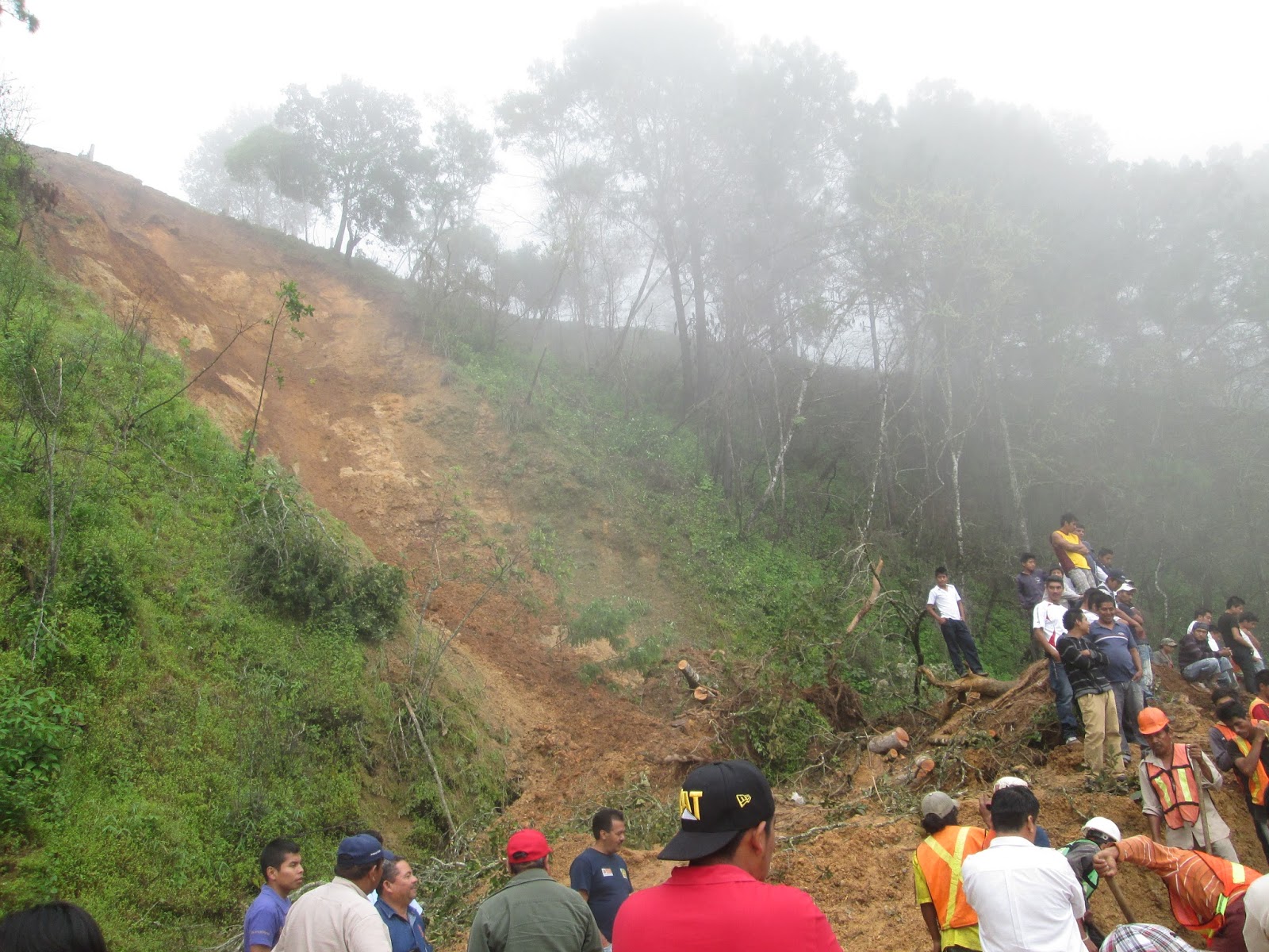
 I wasn’t able to leave until about noon today, but the drive north twisted through dense cloud forest so gorgeous that it made all the back-and-forth steering contortions worthwhile. The road sign pegged Motozintla at 30 kilometers, and Comitán was a few hours past that. Rounding a curve, a line of cars and trucks idled with their hazards on, and I did the same. One by one the engines went silent, so I followed suit and asked what was going on. A landslide, they said, it’s been here since this morning and it’s a few kilometers ahead.


Well, it was more like ten minutes walking until the front of the line, where a huge stripe of mud and trees had skidded into the roadway. Thirty men with shovels barely dented the surface of a hill some fifteen feet high. Combis, the vans used for regional public transportation, discharged their passengers close to the muck on both sides, and people carefully climbed over to continue their journeys with combis on the other side. Folks near that front of the stagnant queue said that the mud had dislodged early in the morning and amazingly no one had been hurt.


So it was a morning of frenzied and needless rushing, followed by an entire afternoon waiting for an earth mover to scrape the road. And perhaps a nudge for me to slow down my schedule and take things at a more relaxed pace.

Saturday, September 7, 2013

Water-logged Tabasco

You can't talk about Tabasco without talking about water. With its cacophany of rivers, swamps, and blobs of land in between, the geography of this southern Mexican state looks like a toddler's squiggle drawing - though one dotted with scores of PEMEX oil drills. Somehow I always end up researching here during the rainy season, when major flooding becomes routine and the TV news kicks off with footage of families being rescued by boat.

I swung up to the northeast corner of Tabasco today for a quick visit to the Pantanos de Centla Biosphere Reserve, a massive and biodiverse wetland and river delta. Huge iguanas lumbered along the raised wooden boardwalk of the reserve's interpretation center, and chunky islands of waterlilies flew by on the river current. Driving back to the main road, I stopped to marvel at a house completely surrounded by a swampy tide and accessible only via a skinny walkway. One of the residents invited me in, but first I had to embarrass myself by inching across the wobbly planks as his family giggled and encouraged me to walk with confidence. Inside the dirt floor room, a woman cooked over a fire, three 'tween girls thumbed through bilingual dictionaries to do their English homework, and I chatted with the ten inhabitants as we waited for the rain to let up.  


Every so often you rush through a place and wish you'd been able to linger and explore it more deeply. Last night I stayed over in Tapijulapa, a little town that dazzled me a few years ago with its cobblestone alley streets, red tile roofs and never-ending green mountain ridges. It reminded me of some of the towns - mostly Spanish - I've visited in the Pyrenees, except with little kids sidling up to me to ask where I was from. 


Thursday, February 14, 2013

Invierno, al fresco

It's been a really difficult year. I usually fantasize about the Sierra summer backpacking season all damn winter, but the months of obsessing just didn't seem healthy this time around. I wanted to get out there NOW, even if I had to risk snow-dusted equipment and the baffled looks of friends.

When things get tough, for me it always feels good to get outside and move around. But the conditions this time of year can be pretty challenging. Like what do you do when the temperature's below freezing and liquid turns to slush in your water bottle? How about when your boots freeze into rigid blocks and you can't get your feet back inside them?

And lo and behold, I discovered that the local Sierra Club organizes snow camping trainings for fools like me. I could meet other deprived backpackers who didn't mind trudging through high altitude snowdrifts in search of their nature fix. Obsession solved.


After the last few years of sola adventures, I was a bit skeptical about joining a big group outing, but the weather was kind and my fellow snowshoers (unsurprisingly, mostly fellows) were a friendly group of outdoorsy folks who were psyched to learn about survival tips like digging snow trenches (below) and the intricacies of Leave No Trace in winter. My comrades-in-cold also delighted in finding animal tracks in the crusty snow, a trait I always find endearing.


Everything was hunky dory during the day, but after sunset I began fondling the brandy flask, popping hand warmers into my gloves and worrying about the circulation in my frigid toes. Sure, the temperature skirted the low 20s and I was socializing in a snowfield, so numb extremities were no surprise. I finally tore myself away from gazing at a ceiling of stars and dove inside my down bag, where I spooned Nalgene bottles filled with hot water. Unfortunately, it was still damn cold. Every hour or so, I tried to calculate how much heat I'd lose by unzippping to don more clothes, which didn't add up to the most restful night.

So next time I'll wear more clothes to bed. And definitely skip the summer hiking boots. But this all-season mountain thing may be a game-changer. We'll see.

Thursday, October 25, 2012

Ready for the dead

It's that time in Mexico. Painters are furiously whitewashing the cemeteries, and flower sellers are stockpiling their sweet-smelling inventory - especially sunset orange marigolds - to get everything in place for Day of the Dead.

I'm currently on the road in the Yucatán for Moon Handbooks, breezing along some of the back roads (read: potholes) connecting the major sights here. Daylight seems to be slipping into the trees earlier and earlier every evening, and yesterday I shut down my overachiever tendencies and spent the night in a nondescript transit town instead of pushing on in the twilight.

So I was walking the streets of Tizimín this morning after breakfast, and talked to these guys prepping flowers for sale next week. The floor of their shop was awash in leaves and stems, as was the street outside.

Tonight I'm in the town outside Chichén Itzá, where December 2012 is reaching a fever pitch and everyone's offering tongue-in-cheek "end of the world" packages and the archaeological site is revamping its sound and light show to capitalize on the influx on Maya doomsday revelers.


Tuesday, September 4, 2012

Four seasons on the JMT


I  didn't start backpacking in the wilderness until I was an adult. My first trip was organized by friends of friends, and we were a group of six women with varying amounts of backcountry experience. I still wince thinking about the slip-on leather shoes that gave me blisters within a half an hour and the hip belt-less pack I carried, but I'll always remember scrambling to a natural rock pool and skinny-dipping in the 90-degree afternoon heat.

I started backpacking by myself a few years ago, mostly because I couldn't find anyone game for longer hikes. Before setting out the first time, I geeked out overpreparing myself. I borrowed library books on wilderness first aid, lurked around online backpacking forums for gear pointers and read up on the most effective bear hazing techniques. My bicycle suffered benign neglect as I walked everywhere for weeks, loading up my backpack to hike home with big grocery shops or ambling miles over San Francisco hills and back to meet friends. I also read Bill Bryson's A Walk in the Woods and thought: if those jokers can take a stab at the Appalachian Trail, I can plod along a well-marked footpath without requiring a search and rescue team.

So after four summers, I recently finished section-hiking the John Muir Trail. Hurrah! If not for the snow-packed Sierra Nevada passes last summer, it would have been three seasons, but no sense dwelling on that.

After logging all those miles on the trail, one sticky issue keeps swirling through my brain: where are all the girls? I hiked alongside a dozen Boy Scout troops and scores of father-son duos, but encountered only one group of girls (a Girl Scout group from SoCal) during that entire time. Besides the ubiquitous Boy Scouts, most of my fellow hikers were men going solo (beard mandatory), groups of male friends (duuude!) or men with their female partners. And so few women hike alone that almost everyone I met assumed I was there with someone else.

So why aren't more girls trekking the trails? It bugs me that it's such a boys-only (and mostly white) rite of passage. If no one takes them into the wilderness, how are girls going to learn the self-reliance and camaraderie found there, or a deeper respect for the natural world? I'm committed to change those statistics as best I can, and I hope that other folks will do the same. 

If you're wondering why it's worth slogging over mountains with a heavy pack and digging catholes every day, I'm posting a few photos from the southernmost section of the JMT (accessed via Onion Valley) below.

Kearsarge Lakes

Forester Pass facing east

Bighorn Plateau

Guitar Lake basin

Sunrise over ridges west of Whitney

View from Mt Whitney

Saturday, July 14, 2012

Venezuela in photos

Blame it on the road, but I've been too exhausted to do much more than hit the pillow every night. Here are a few photos to narrate my trajectory over the last few weeks.

In Caracas, and soon to open as the new resting place for Simón Bolívar. Some have derided it as overpriced ski slope architecture, but it does mirror the upward slope of El Ávila behind it.

Flying in over Gran Roque, the main settlement in Los Roques. Most of the houses on the island are on the righthand side, next to the lagoon.

An astillero, or boat-building yard, along the northwest coast of Isla Margarita. I think it looks like the skeleton of a whale.

A worker preparing tobacco leaves in a cigar factory in Cumaná.


I noticed this store in Puerto Ordaz during my first visit to Venezuela back in 2006. When I asked them about the name, the folks working there had no idea where it came from.


One of my biggest disappointments was just missing the arrival of presidential candidate Henrique Capriles Radonski at the airport in Ciudad Bolívar, but my plane was leaving for Canaima. Hundreds of flag-waving supporters mobbed the airport- a true rockstar moment.


Dusk at Playa Medina, along the northeast coast near Rio Caribe. I hired a taxi to drive me to remote beaches along the coast all day, and this was the last one. We drove back in the dark along a road that had more holes than pavement. Wish I could have stayed here instead. 


Bus . . . or boudoir? One of my many experiences with unusual interior decorating on public conveyances.